

Most people who visit Arches National Park stay on pavement. They drive the main road, park at the trailheads, hike to the arches, and head back to Moab. That’s fine. The park rewards that approach. But there’s a different version of Arches that only opens up if you have a capable rig and the willingness to leave the asphalt behind.
This guide covers the Eye of the Whale OHV route in Arches National Park: what you need to drive it, how to find it, what to expect on the road, and how to build a full Moab day around it.
Quick Facts
| Route Name | Eye of the Whale OHV Route |
| Location | Arches National Park, near Moab, Utah |
| Coordinates | 38.7034° N, 109.5716° W |
| Distance | Approx. 5 miles roundtrip |
| Elevation Gain | Approx. 400 feet |
| Difficulty | Moderate (high-clearance 4WD required) |
| Time | 2-3 hours |
| Dogs Allowed | No |
| Fee | $35 per vehicle (America the Beautiful Pass accepted) |
| AllTrails | View on AllTrails |
How to Get There
Arches National Park sits 5 miles north of Moab on US-191. Enter the park at the main entrance, pay the fee or show your America the Beautiful Pass, and drive the main park road north. Pass Balanced Rock and continue toward the Windows Section. Before you reach the Windows turnoff, watch for the signed Willow Springs Road on the left, an unpaved road that heads northwest into the backcountry.
Willow Springs Road is where the pavement ends and the real driving begins. Follow it to the Eye of the Whale trailhead area. The route isn’t long in miles but takes time because of the terrain. Don’t rush it.
From Salt Lake City, expect about 4 hours to Moab via I-15 south and US-191. From Grand Junction, Colorado, it’s roughly an hour west. If you’re not already in Moab, plan your lodging there the night before so you can start early.
Important: timed entry reservations are required at Arches during peak season, generally April through October. Book your entry window at recreation.gov before arriving. Without one, you may not get into the park at all during busy periods.
Cell Service and Navigation
Cell coverage in the Arches backcountry is essentially nonexistent. You’ll have signal near the visitor center and entrance but expect to lose it well before Willow Springs Road. Don’t count on Google Maps or any live data once you’re off the main park road.
Download your navigation before you go. The NPS Arches app has offline capability, and AllTrails has the route mapped with the ability to track your GPS position without data. Get both downloaded while you’re in Moab or at the park visitor center Wi-Fi. A paper map of the park is also worth having in the glove box. Old school still works out here.

What to Expect on Eye of the Whale
The Road
Willow Springs Road is classified as a backcountry road requiring high-clearance 4WD. That means you need actual 4WD engaged, not AWD, and actual ground clearance, not a lifted appearance package on a crossover. The road starts rough and stays that way.
Expect loose rock, embedded sandstone, soft sandy washes, and sections where route-finding requires attention. The road is generally well-tracked from prior use, but it winds through terrain that punishes inattention. Go slow. Let the vehicle work. Dropping tire pressure to 20-25 PSI improves traction significantly on the sandy stretches.
The surrounding landscape is remote Arches backcountry at its best: sweeping sandstone fins, open desert flats, and a silence that the main park road never quite achieves. You’ll likely have it largely to yourself, especially on weekdays.
The Arch
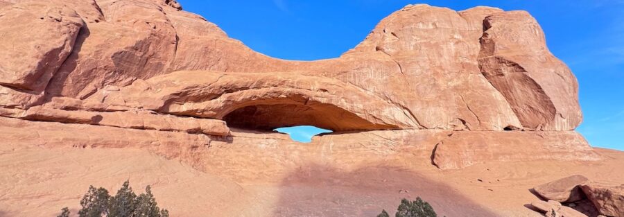
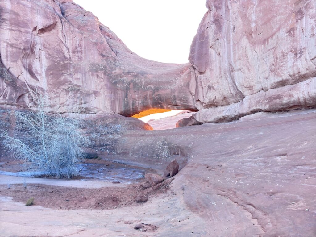
Eye of the Whale Arch is an elongated oval opening in a sandstone fin, roughly 20 by 30 feet, that frames sky and canyon wall in a shape that genuinely resembles a whale’s eye in profile. It’s not the largest arch in the park. It doesn’t try to be. But its isolation and geometry make it memorable in a different way than the marquee arches on the main corridor.
A short hike from where you park brings you to the arch. Scramble the sandstone and you can step through the opening. The views from the arch look back across open desert toward the park interior, with no other visitors and no interpretive panels telling you what to think. That’s the experience.
Drive Difficulty and Length
The route runs approximately 5 miles roundtrip with around 400 feet of elevation change. Neither figure sounds dramatic on paper, but the terrain makes this feel more substantial than the numbers suggest. Figure 2-3 hours for a comfortable out-and-back with time at the arch, longer if you stop to explore side formations.
Difficulty is moderate for experienced off-roaders with appropriate vehicles. For drivers newer to 4WD terrain, it sits toward the upper end of moderate. The route doesn’t have extreme obstacles, but it does require sustained attention and a willingness to read terrain. If you’ve never driven a 4WD route before, go slow and trust the vehicle.
Dog Friendly?
No. Arches National Park prohibits pets on all unpaved surfaces, including backcountry roads. Your dog cannot accompany you on Willow Springs Road or the approach to Eye of the Whale. Pets are allowed in parking areas, campgrounds, and on paved roads within the park, but must be leashed at all times.
If you’re traveling with a dog, plan a Moab day that mixes park visits without the dog and dog-friendly BLM trails outside park boundaries. Corona Arch and Hurrah Pass are the best dog-friendly options.
What to Bring
For the vehicle: a recovery kit if you’re going without a group. That means a tow strap, a shovel, and ideally a hi-lift jack. Sand is the most common issue on Willow Springs Road, and airing down tires is the first fix. A portable air compressor to re-inflate when you’re back on pavement is essential.
For you and any passengers: water, at minimum 2 liters per person. Sun protection. Snacks. A paper map of the park. Sturdy shoes for the scramble to the arch. A camera with a wide-angle lens for the arch framing.
For communication: a satellite communicator like a Garmin inReach is worth carrying in remote areas of Arches with no cell service. If something goes wrong with the vehicle in the backcountry, that device is your link to help.
Best Time to Drive Eye of the Whale
Spring and fall are the prime windows: March through May and September through November. Temperatures are manageable, the light in the sandstone country is warm and angled, and the backcountry roads are dry.
Summer is punishing. The backcountry has zero shade and the exposed slickrock radiates heat in a way that accelerates dehydration and fatigue. If you go in summer, leave before sunrise, be back at the vehicle by midday, and carry more water than you think is reasonable.
Winter can bring snow and ice to Willow Springs Road, which complicates a route that already demands attention. Check conditions with the Arches visitor center before committing. The park staff are straightforward about road conditions and will tell you honestly whether the road is passable.
For photography, the arch faces east-southeast, which puts it in good light during the morning hours. Plan to be at the arch by mid-morning for the best angle. Golden hour after sunrise, if you can get there early enough, is the ideal window.
Rules and Regulations
Stay on designated roads and trails. Arches has fragile cryptobiotic soil crust throughout the backcountry that takes decades to recover from a single tire track off-route. Drive only on established roads. Do not create new tracks.
No pets on unpaved roads or trails. Pack out all trash. Fires are prohibited in the backcountry. Drone use requires a special permit that Arches rarely grants. Timed entry reservations are required during peak season, booked at recreation.gov. The $35 vehicle fee or America the Beautiful Pass covers park entry.
If a route is signed as closed, it’s closed. Flash flood risk is real in slot canyons and sandy washes. Check the forecast and ranger bulletins before heading into the backcountry.
Where to Stay Near Moab
Moab is the base for Eye of the Whale. The town sits 5 miles from the park entrance and has lodging across every budget range. Red Cliffs Lodge sits on the Colorado River on Highway 128, about 14 miles from Moab with rooms overlooking the river canyon. For points travelers, check available Marriott Bonvoy properties in Moab, IHG Rewards hotels near Moab, and Hilton Honors options in the area. Spring availability in Moab moves fast. Book ahead.
Camping Nearby
Inside Arches, Devils Garden Campground is the only developed option and books out months in advance on recreation.gov. Worth planning ahead if you want to camp inside the park.
Outside the park, the BLM land around Moab offers dispersed camping at Gemini Bridges, Porcupine Rim, and the Sandflats Recreation Area. Sandflats has both dispersed and fee sites and is close enough to Moab to be a convenient base. For OHV-specific camping, the Sandflats area is the standard choice since it’s the hub for most of Moab’s 4WD routes.
Nearby Adventures
Tower Arch is the other major backcountry arch in the Klondike Bluffs area of Arches, accessed via a different unpaved road from the northwest corner of the park. It’s a comparable commitment in terms of vehicle requirements and offers a less-visited alternative arch experience. Worth combining with Eye of the Whale if you’re spending a full day in the Arches backcountry.
Klondike Bluffs, in the same northwest section of the park, offers a hiking trail that’s significantly less crowded than the main corridor. If you have a passenger in your vehicle who’d rather walk while you drive, that’s an option worth knowing about.
Back on pavement, hiking Delicate Arch is the iconic Arches experience. The Windows Loop and Turret Arch and Double Arch Trail round out a full day inside the park.
For more Moab OHV terrain outside the park, the Sandflats Recreation Area has Fins and Things, Hell’s Revenge, and Slickrock Bike Trail (the latter being famous for mountain biking but also passable in capable 4WD rigs). Longer routes include Gemini Bridges and Hurrah Pass.
In town, Quesadilla Mobilia and Canyon Pizza handle post-adventure food well. The Colorado Riverway scenic drive on Highway 128 northeast of Moab is worth doing if you haven’t, especially in late afternoon light.
Plan This Drive
AllTrails has the Eye of the Whale route mapped with GPS tracking and offline capability. Download it before you leave Moab, since you’ll have no data once you’re on Willow Springs Road. The app also pulls recent condition reports from other drivers, which is useful for knowing current road state. Plan your drive on AllTrails and save the offline map while you’ve still got signal.
Chase the Quiet
There’s a particular kind of quiet in the Arches backcountry that you don’t get on the main park road. No shuttle buses. No crowd noise drifting from the trailhead. Just the sound of wind across sandstone and the particular creak of a hot desert cooling down. Eye of the Whale gives you that. It makes you work a little for it. You need the right vehicle, a little willingness to navigate uncertain terrain, and the patience to drive slow when slow is what the road asks for. What you get in return is an arch that most visitors to Arches National Park will never see.
Support the Adventure
To make your walls less boring, check out my photography portfolio and bring a piece of the wild and my story into your home.
If you’d like to fuel future adventures, you can donate a coffee on Ko-Fi. Every cup keeps me chasing sunrises and stories.
When you shop using my affiliate links, every click helps support this blog at no extra cost to you. It’s a small way to keep Unicorn Adventure alive and kicking while I keep exploring.
Subscribe to my mailing list for future updates, new stories, and behind-the-scenes adventures.
Stay connected with me on Instagram and Facebook for more photos and daily inspiration.
Thanks for being part of the journey, Unicorn Squadron!

Theo Maynard is a landscape photographer and adventure blogger based in Salt Lake City. He chases remote desert and mountain light across the American West, documents it all solo, and shares the journey through Unicorn Adventure. He’s on the autism spectrum, and that’s not a footnote, it’s the whole story. He creates to inspire others to get outside, chase what lights them up, and live their best possible life. Unapologetically himself.